|
Introduction
Prerequisites(s)
The following information would be helpful in order to successfully
accomplish this activity.
- Suggestion one: Know what the icons mean.
- Suggestion two: Know how find the area formula for
each shape.
- Suggestion three: Look over the links below concerning
salt production and geometric shapes.
Standards Addressehttp:
- S2.4 Compute length, perimeter or circumference, area,
volume, and surface area of
geometric figures with missing information and correctly identify the
appropriate unit
of measure of each.
- S2.5 Use geometric tools (e.g., protractor, compass,
straight edge) to construct a variety of
figures.
Instructions
- Accessing Project
- Download the resource Woods County Satelite Image. (This will
take quite a while, the file is very large) If possible,
your teacher needs to download this file the day before and have
it located where students may access it faster.
- Click the 'Extract all files' from the folder task menu on the
left.
- Choose My Documents as the location
to extract to, click finish when done.
- Download the Garfield Count Projects Resource
- Click the 'Extract all files' from the folder task menu on the
left.
- Choose My Documents as the location
to extract to, click finish when done.
- Click HERE
for instructions on how to assemble the Garfield County Project.
- Once you have assembled the project, open the folder named Woods
Project.
- Open the fGIS program by pressing on the
 icon.
icon.
- Double click the "FGIS" folder and open the #1 file.
- Select the Measure project file, which should be listed in menu
as an option.
- If this is your first time using fGIS, access the video Tour
to get started.
- Lesson Instructions
- As per teacher instructions, print off a copy of the map that
automatically appears. Do this by selecting
- Map >
- Print >
- Simple Map > and then
Enter your name in the footer space provided in the popup window
and click okay.
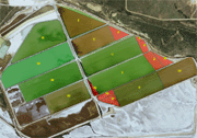
- Frist click on the word Geoshapes in the left hand colum. It should
be highlighted blue.
-
For Polygons 2, 4, 7, 13 and 14 measure the
length and the width in meters.
Steps: First click on the icon  .
Then find the number that you need calculate and click on it for
the acre number. Area equals ½ base x height for triangles.
-
For the triangle polygons 1, 3 and 6 measure
the length and the width in meters
Steps: First click on the icon .
Then find the number that you
need calculate and click on it for the acre number.
-
For rectangles 5, 12, 7 and 10 use the measure
tool to find the height and length of the rectangle then add the
height and length using the feet measurment. the length and the
width in meters
Steps: Click on the measuring tool .
Then very carefully use the zoom tool the circle with the plus
sign on it, and click on the number rectangle at one end and double
click on the other.
- For the remaining shapes 8, 9 and 11 use the measure tool to find
the height and length of the rectangle then add the height and length
using the feet measurment.
Steps: Click on the icon
then click the shape you need to get the length, height, and acre.
|
|